Tactical Observation
Rapid deployment, distributed observation and multi-camera coordination, with the operator in control.
Explore
Mission intelligence
Sensor fusion and AI-assisted prioritization for a unified operational picture.
Value statement
A sensor-fusion and mission-intelligence software layer. AI recommends. The operator decides.
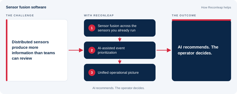
Distributed camera and sensor environments produce more information than teams can review manually.
Overview
ReconOS is sensor fusion software, and this summer its drone detection was tested several times in Israel, in very different conditions, with IP cameras and edge AI. Spotting a small drone early enough to react is the hardest part of counter-UAS (C-UAS) work, especially when the target is only a few pixels wide.
On 25 June 2026 at the Adam Training Facility, operators flew a 5-inch drone at 50 m altitude while other defense bodies watched. The ReconOS day channel, running a sub-pixel detection algorithm, demonstrated detection of the drone against open sky at about 1,700 m. A compact thermal channel located it at under 400 m, and it was the channel that picked the drone out against a tree background.
On 27 July, a multi-vendor evaluation run by Israeli defense authorities set a harder task: detect a 10-inch drone against vegetation, scored by the time to first detection. Control was handed to the test controllers, with no company intervention. ReconOS gave early detections, sometimes several seconds before other solutions, and the report credits it with the longest warning time.
The trials also showed where the limits are. Optical sensors need line of sight, so sensor placement matters, and several inexpensive sensors can cover more ground than one expensive central unit. As sensor fusion software, ReconOS runs on ReconOps, a portable edge control unit that powers up to four PTZ cameras over a 300 m cable, and it works with the IP cameras you already have.
For teams protecting airspace, perimeters or forward positions, the takeaway is practical: camera-based drone detection built on sensor fusion software works best as a layered setup, with the right sensors in the right places and an operator who stays in control of every decision. The full report covers the flight table, range ladder, test setup and the lessons we took from the trials.
Key capabilities
One view across distributed sensors.
Scalable mission visibility.
Designed to help teams focus attention where it matters.
Clear evidence for each decision.
Human authorization stays in the loop.
Works with the sensors you already run.
System architecture
AI recommends. The operator decides.
Deployment workflow
Integrate fixed cameras, PTZ systems, and distributed sensors.
Run video analytics and mission workflows locally at the edge.
Turn detections and events into a ranked operational picture.
Keep the operator in control with clear evidence and rapid access to relevant footage.
Technical specification
Detailed specifications are shared on request.
Related mission environments
Rapid deployment, distributed observation and multi-camera coordination, with the operator in control.
ExploreContinuous observation with detection, verification and event review across long perimeters and protected facilities.
ExploreObservation where fixed power and network infrastructure are unavailable, using solar and battery power, local processing and detection-only modes for constrained links.
ExploreWide-area observation and fast review of changes, organized into a prioritized operational picture.
ExploreTemporary deployments with flexible camera integration and operator-assisted monitoring for events and public spaces.
ExplorePersistent observation, alert verification and event review around sensitive underground-access locations, plus camera inspection inside shafts.
ExploreVisual monitoring of mine shafts, entrances and exclusion zones for site security, safety workflows and remote supervision.
ExploreMonitoring and event verification for parked aircraft, aprons, remote stands and airside areas.
ExplorePrivacy-conscious monitoring of campground entrances, parking, facilities and perimeters, with verified alerts and event review.
ExploreFAQ
The operator. AI-assisted prioritization with human authorization.
See how Reconleap can connect sensing, edge intelligence, and human decision-making for your operational environment.