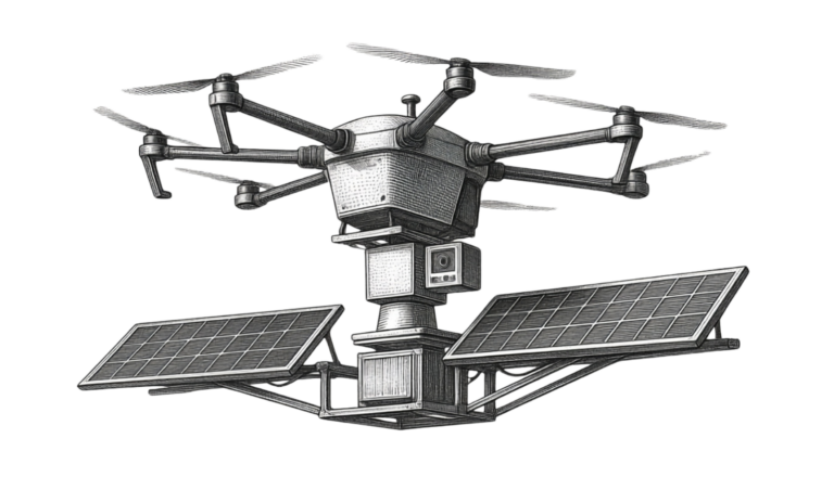
Hundreds deployed in the IDF
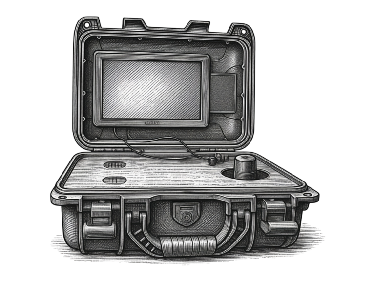
Mission management
ReconOps
Portable mission management for multi-camera observation, analysis, and operator control.
View ReconOps
Mission environment
AI-assisted visual detection and tracking of drones and other low-altitude objects, on the cameras you already run.
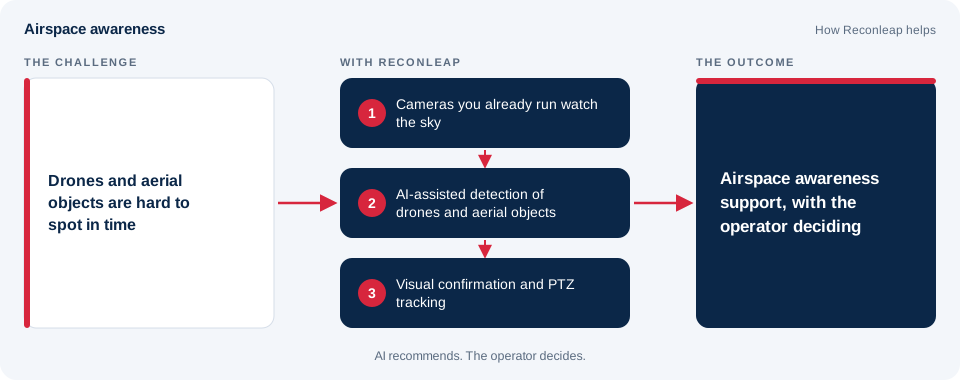
Airspace awareness is knowing what is in the air above and around a place you are responsible for. For many sites that now includes small drones and other low-altitude objects, whether they are harmless, lost or simply unexplained.
Airspace awareness support, as described here, uses the cameras you already run. AI looks for aerial objects in the video, the operator confirms what each one is, a PTZ camera can follow it, and the event is recorded. It is about seeing, confirming and recording. Decisions about what to do next stay with the operator and the people responsible for the site.
| Role | What they usually need |
|---|---|
| Security managers at protected facilities | Awareness of aerial objects near the site, without adding people to watch the sky. |
| Event security teams | A way to notice and record aerial objects above a venue during an event. |
| Operators at tactical positions | Aerial objects flagged from the feeds they already have, for the operator to confirm. |
| Infrastructure and site managers | Evidence and a clear record when something unexplained is seen overhead. |
| Integrators and consultants | A layer that works with cameras that are already installed. |
A protected facility with cameras already installed. Staff keep noticing unexplained aerial objects near the boundary, but nobody can watch the sky all day. AI flags aerial objects in the existing feeds, the operator confirms what each one is, and the clip is kept for review.
An outdoor event. A venue wants to know when drones are overhead during an event. Cameras at key points feed one operator view, flagged objects are confirmed visually, and a PTZ camera can follow one for a closer look.
A temporary position with limited connectivity. A team in remote terrain needs awareness of the sky without a steady link. Processing runs locally, and a solar-powered node can be used where there is no fixed power.
These scenarios are illustrative examples of how the approach is used. They are not customer case studies.
| Stage | What happens | Who acts |
|---|---|---|
| Detect and confirm | AI flags an aerial object in the video and presents it for visual confirmation | The system, then the operator |
| Track | Operator-controlled PTZ follows the object, with enhancement and stabilization | The operator |
| Alert and record | Alerts and event clips are kept for review | The system |
| Decide | The operator decides what happens next | The operator |
| Challenge | Why it is hard | What helps |
|---|---|---|
| Small and fast | A small object can cross the view quickly and be easy to miss | AI watching every feed, so the operator is not the only line of detection |
| Hidden in clutter | Cloud, terrain, buildings and trees make the background busy | Visual confirmation, plus image enhancement and stabilization |
| Look-alikes | Birds and other objects can resemble what you are looking for | An operator confirming each flagged object before anyone acts |
| Several at once | More than one object can be in view at the same time | Alerts that show the operator where to look first |
| Many feeds | Nobody can watch every camera continuously | Operators confirm flagged objects instead of scanning every feed by eye |
| Topic | What to expect |
|---|---|
| Visibility | Cameras depend on light and weather. Fog, heavy rain and glare can reduce what any camera can show. |
| Distance | Smaller or more distant objects are harder to see. Results depend on the camera, the lens and the setup. |
| Field of view | A camera sees only what is in its view, so placement matters. |
| Confirmation | Detections are prompts. The operator confirms what was seen. |
| Layering | Optical detection is one source of information. Some sites also want other sensors in the picture. |
This table is general guidance. Results depend on your site and configuration, and we do not publish performance figures.
Airspace awareness support is one part of a wider set of mission tools. This is what each capability does and why it matters to an operator.
| Capability | What it does | Why it helps |
|---|---|---|
| Multi-camera command and control | Centralized live viewing, recording and PTZ control across the connected cameras | One operator can work from one view instead of switching between systems |
| Airspace awareness support | Optical detection of flying objects, with visual confirmation and operator-controlled PTZ tracking | The operator sees and confirms what was flagged |
| Image enhancement and stabilization | Cleans up and steadies the picture in challenging field conditions | Gives both the AI and the operator a clearer view |
| Edge AI mission management | Analytics and mission management run on the device, close to the cameras | The system keeps working over limited connections |
| Day-in-a-Minute review | Automated review of a selected time period that condenses relevant changes into a short clip | Quicker after-action review without watching everything |
| Recording and data distribution | Local recording of event clips and snapshots, with the option to send events only | Evidence for review, and reporting that matches the bandwidth available |
Airspace awareness support can be delivered with ReconOps or with ReconHop. This table shows how they differ so you can see which suits your site.
| Consideration | ReconOps | ReconHop |
|---|---|---|
| What it is | Portable mission management for multi-camera observation, analysis and operator control | A solar-powered observation node for off-grid and remote environments |
| Best suited for | Positions and sites that have or can bring cameras and need one operator view | Remote sites with no fixed power |
| Cameras | Works with the fixed and PTZ IP cameras you already run | Includes a long-range optical PTZ camera |
| Power and setup | Portable, designed to deploy without relying on fixed infrastructure | Solar and battery power, so a site can go live without a cable run |
| Connectivity | Can send events only, to match the bandwidth available | Cellular connectivity, with a detection-only mode for constrained links |
| How operators use it | Hands-on PTZ control and one view across the connected cameras | Operator-controlled PTZ tracking from wherever the operator is |
Not every combination suits every site. Describe your site, cameras, power and connectivity in a briefing and we will help assess the right setup.
| Consideration | Why it matters | Things to check |
|---|---|---|
| Open view of the sky | Obstructions block the view of aerial objects | Trees, buildings and masts near the camera |
| A stable mount | Movement makes footage harder to use | Wind exposure and the strength of the mounting |
| Background | A busy background makes objects harder to pick out | Cloud, skyline and the direction of light at different times of day |
| Overlap | Several cameras can cover each other's gaps | Where the fields of view meet |
| Access and security | Equipment needs to be reachable and safe | Power, cabling and who can reach the mount |
| Question | Why it matters |
|---|---|
| Which cameras do you already have, and where are they? | Existing fixed and PTZ IP cameras may be usable. |
| What does the sky view look like from each position? | Obstructions and background shape what can be seen. |
| What power and connectivity are available? | These help decide between a portable case and a solar-powered node. |
| Who confirms what is flagged, and how do they respond? | The confirmation routine shapes how alerts are presented. |
| What are the local rules about drones and recording? | Rules on drones, airspace and recording differ by place. |
| How long should recordings be kept, and who may see them? | Retention and access should be agreed before use. |
ReconOps provides portable mission management for multi-camera observation, analysis and operator control, and adds airspace awareness support to the cameras you already run. Where there is no fixed power, ReconHop is a solar-powered observation node for off-grid and remote environments. Analytics run locally, so the system keeps working over limited connections.
See Technology for how the pieces connect, and Field readiness for how the system works beyond fixed infrastructure.
Reconleap is designed to work with the cameras you already run, including fixed and PTZ IP cameras. There is no rip-and-replace. Tell us what you have and we will help assess where it fits.
AI flags an aerial object in the video and presents it to the operator for visual confirmation. The operator can use PTZ tracking to follow the object for a closer look. AI recommends. The operator decides.
It is aimed at drones and other low-altitude objects. If you have a specific kind of object in mind, ask in a briefing and we will tell you what is supported.
Optical detection depends on visibility, so weather, light and distance all matter. Image enhancement and stabilization help in challenging field conditions, but we do not publish performance figures. Describe your site and conditions in a briefing.
Solar-powered ReconHop nodes are designed for sites without fixed power, and analytics run locally. Site conditions shape what is practical, so describe the location in a briefing.
Alerts, event clips and recording are kept as evidence for after-action review.
This page describes awareness: detecting, confirming, tracking and recording. The operator decides what happens next, and any response belongs with the people and authorities responsible for the site.
Related guide: see how AI video analytics for existing cameras adds detection to the PTZ and fixed cameras you already operate.
Last reviewed October 2026.
Operational challenges
How it works
AI flags aerial objects in the video and presents each one for visual confirmation.
Operator-controlled PTZ follows the aerial object, with enhancement and stabilization.
Alerts, event clips and recording support the response and after-action review.
AI recommends. The operator decides.
Recommended capabilities
Optical-based detection of flying objects with visual confirmation.
The operator stays in control.
Clearer footage in challenging field conditions.
Evidence for after-action review.
Operational value
AI watches every feed and flags aerial objects to the operator.
Operators confirm flagged aerial objects instead of scanning every feed by eye.
Fixed and PTZ IP cameras. No rip-and-replace.
A rugged portable case, or solar-powered ReconHop nodes off-grid.
Deployment context
Deployed with ReconOps, or with solar-powered ReconHop nodes where there is no fixed power. AI recommends. The operator decides.
Related products
See how Reconleap can connect sensing, edge intelligence, and human decision-making for your operational environment.